


")

March 2016 fully equipped test run
This is the final test run before the launch. I plan to leave Port O'Connor at Little Jetties at first light on Monday, 14th March, 2016 and return on Wednesday or Thursday evening. I will be monitoring Marine VHF Channel 20 each evening between 17:00 and 17:30.
 Sunday Beach is
the start of 38 miles (61km) of pristine beach. No RVs, no vehicles at
all, no people, just sand and warm Gulf of Mexico water that is
accessible only by boat. There is usually a cooler breeze coming in
from the sea.
Sunday Beach is
the start of 38 miles (61km) of pristine beach. No RVs, no vehicles at
all, no people, just sand and warm Gulf of Mexico water that is
accessible only by boat. There is usually a cooler breeze coming in
from the sea.
Sixteen miles SW of the J-hook is the wreck of the Darlington concrete ship. The Matagorda Island Lighthouse (1852) is 3.7 miles SW of Sunday Beach and a quarter of a mile from the beach.
March 14th trip—disaster
 The day
started out badly and got worse; much worse. The weather forecast was
for sun with a light breeze (perfect for photography). When I left
Houston it was foggy. By the time I got to Port O’Connor (8:00am at
Little Jetties), I couldn’t even see more than 100 feet. ⇒
I checked the
NOAA VHF Weather Service and the wind had picked up to
10mph SSW (not good). I decided to wait two hours and re-evaluate.
During this period it would clear up and then the fog would roll back
in. I could hear boats on the Intracoastal Waterway (ICW) but couldn’t
see them. I had such high expectations for this trip and didn’t want
to disappoint myself. So, I waited.
The day
started out badly and got worse; much worse. The weather forecast was
for sun with a light breeze (perfect for photography). When I left
Houston it was foggy. By the time I got to Port O’Connor (8:00am at
Little Jetties), I couldn’t even see more than 100 feet. ⇒
I checked the
NOAA VHF Weather Service and the wind had picked up to
10mph SSW (not good). I decided to wait two hours and re-evaluate.
During this period it would clear up and then the fog would roll back
in. I could hear boats on the Intracoastal Waterway (ICW) but couldn’t
see them. I had such high expectations for this trip and didn’t want
to disappoint myself. So, I waited.
 By
10:00, I could see the end of the jetty on the ICW and decided to set
up the boat and by 11:30 I was ready to go. ⇐
By
10:00, I could see the end of the jetty on the ICW and decided to set
up the boat and by 11:30 I was ready to go. ⇐
As I rounded the pier to go into Matagorda Bay the wind had picked up to 12-14mph and, try as I might, I couldn’t help being driven further and further off course toward the peninsula.
 The
only plus at this stage, was being joined by six or seven dolphins
which were ducking in and out about fifteen feet away from me. I
wanted to take a picture but didn’t dare distract myself with the
waves this high. At 14:02, it was clear I was not going to make it to
Sunday Beach and getting back from the peninsula would be a huge
problem even if I left it to the next day as the weather was supposed
to be worse. So, I decided to turn back. As I had my boat
perpendicular to the wind direction and the waves at about three feet,
I was constantly being hit by waves crashing into the side of my boat
and splashing in. The boat is very stable and I wasn’t worried about
it capsizing but it was, nonetheless, harrowing.
The
only plus at this stage, was being joined by six or seven dolphins
which were ducking in and out about fifteen feet away from me. I
wanted to take a picture but didn’t dare distract myself with the
waves this high. At 14:02, it was clear I was not going to make it to
Sunday Beach and getting back from the peninsula would be a huge
problem even if I left it to the next day as the weather was supposed
to be worse. So, I decided to turn back. As I had my boat
perpendicular to the wind direction and the waves at about three feet,
I was constantly being hit by waves crashing into the side of my boat
and splashing in. The boat is very stable and I wasn’t worried about
it capsizing but it was, nonetheless, harrowing.
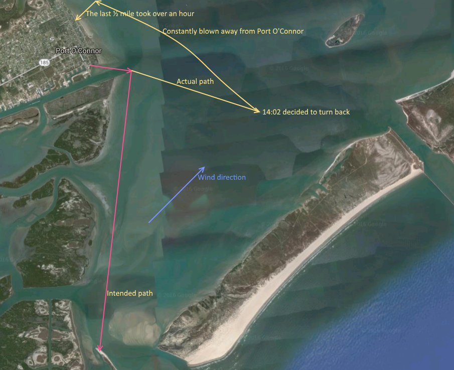 Getting
back to Port O’Connor was just as difficult as I was constantly being
blown further north. I was exhausted! By the time I got close enough
to the coast to choose a landing site I was at the northern edge of
the town and I could see a beach with a pier and decided to head for
that. This meant turning directly into the wind. It took well over an
hour to make it that last ½ mile to the pier. I almost fell over when
I climbed out of the boat as the beach was covered in large shells (I
was wearing Sealskinz socks) and the
shells dug into my feet. A very kind lady from San Antonio (who had
five rescue dogs with her) gave me a lift back to Little Jetties to
pick up my car. I intended to take the red route on the map but ended
up on the yellow route. Another plus was the lessons learned:
Getting
back to Port O’Connor was just as difficult as I was constantly being
blown further north. I was exhausted! By the time I got close enough
to the coast to choose a landing site I was at the northern edge of
the town and I could see a beach with a pier and decided to head for
that. This meant turning directly into the wind. It took well over an
hour to make it that last ½ mile to the pier. I almost fell over when
I climbed out of the boat as the beach was covered in large shells (I
was wearing Sealskinz socks) and the
shells dug into my feet. A very kind lady from San Antonio (who had
five rescue dogs with her) gave me a lift back to Little Jetties to
pick up my car. I intended to take the red route on the map but ended
up on the yellow route. Another plus was the lessons learned:
- Don’t trust the weather forecast (this should be obvious to someone from England)—I bought a portable anemometer.
- A human-powered vehicle has no chance against a strong wind.
- Take the inland route to the J-hook and then stay close to the beach.
Update
 Four
days after I landed with my kayak near the north pier (on the north side),
I realized that I accidentally left a black plastic rib on the grass. I came back to find it only to see the grass had been mowed. The part is large and would have caught in the blades. I subsequently found the manufacturer,
Folbot, went out of business. I will have to make one out of
Alumin(i)um.
Four
days after I landed with my kayak near the north pier (on the north side),
I realized that I accidentally left a black plastic rib on the grass. I came back to find it only to see the grass had been mowed. The part is large and would have caught in the blades. I subsequently found the manufacturer,
Folbot, went out of business. I will have to make one out of
Alumin(i)um.
Well, I really got lucky. I found one on Ebay and the boat is now complete.