


")


Texas Paddling Trails
Coastal Texas Paddling Trails at Port O'ConnorLittle Jetties - corner of S. Washington and Commerce Streets
Little Jetties trail kiosk is at Latitude:
28.4447859°N and Longitude: -96.4028256°W. The Little Jetties site is located on a public right of way where Washington Street dead-ends into the Gulf Intracoastal Waterway (ICW). A small parking lot is available.
 To get to Matagorda Island, the entry is ~0.9 mile from Fisherman's Cut but you can paddle to the left (East) and pick up the route further south past Little Mary's Cut on the Big Bayou.
Or, even further south past Bayucos Island and pick up the trail in Saluria Bayou at First Cut (where the, once thriving,
town of SaluriaGalveston, Texas, Sept. 21,1875
Mr. J. Y. Gilmore: Dear Sir—I avail myself of the first opportunity
that has been afforded me to give a brief account of the great storm
of the 16th and 17th inst., along the coast of Texas, sweeping
hundreds of men, women and children to watery graves, and destroying millions of property.
Morgan's Point, Lynchburg, Indianola, Saluria, Decrow’s Point
and Galveston, with many other places, were either seriously crippled or totally destroyed.
To get to Matagorda Island, the entry is ~0.9 mile from Fisherman's Cut but you can paddle to the left (East) and pick up the route further south past Little Mary's Cut on the Big Bayou.
Or, even further south past Bayucos Island and pick up the trail in Saluria Bayou at First Cut (where the, once thriving,
town of SaluriaGalveston, Texas, Sept. 21,1875
Mr. J. Y. Gilmore: Dear Sir—I avail myself of the first opportunity
that has been afforded me to give a brief account of the great storm
of the 16th and 17th inst., along the coast of Texas, sweeping
hundreds of men, women and children to watery graves, and destroying millions of property.
Morgan's Point, Lynchburg, Indianola, Saluria, Decrow’s Point
and Galveston, with many other places, were either seriously crippled or totally destroyed.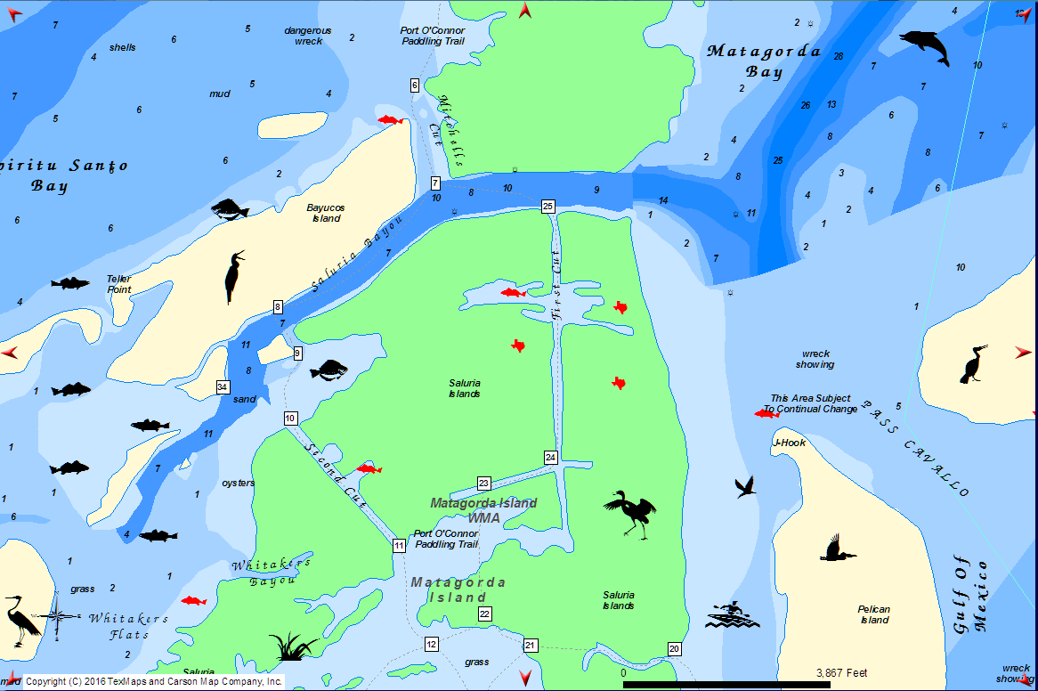 was). However, I don't recommend this unless there is no wind as once you round the ICW jetty, you are exposed to the full wind of the bay (see problems I had in
March 2016).
was). However, I don't recommend this unless there is no wind as once you round the ICW jetty, you are exposed to the full wind of the bay (see problems I had in
March 2016).
You can also take the shortest route via the boat ramp where Lane Rd, Seadrift dead-ends into the Gulf ICW. This goes through the cut opposite the ramp and across Espiritu Santo Bay in a straight line to the camp site. You are very likely to be joined by curious pairs of Bottlenose Dolphins. When you come out of the cut take a bearing of 105° for a distance of 11km (6nm or 6.8 miles). Again, wind direction and speed should be considered here as you are exposed in Espiritu Santo Bay.
The rich history of Matagorda Island and, in particular,
Saluria
and ") Fort Esperanza is covered in this article from
Texas State Historical Association. The Southwestern Historical Quarterly, Volume 61, July 1957 - April 1958, H. Bailey Carroll, editor, pp. 66-100.
More details on Fort Esperanza (Debray) are
here.
Fort Esperanza is covered in this article from
Texas State Historical Association. The Southwestern Historical Quarterly, Volume 61, July 1957 - April 1958, H. Bailey Carroll, editor, pp. 66-100.
More details on Fort Esperanza (Debray) are
here.
Saluria, Fort Esperanza, and Military Operations on the Texas Coast, 1861-1864
by Lester N. Fitzhugh (the capture by Union troops was also
reported in the
New York Times by Col. H.D. Washburne and in Camp & Field in the
march, from Indianola to Saluria, of
The Old 16th Ohio regiment by Cpl. Theodore D. Wolbach, Company E). Saluria's street names were named after
trees/plants running N-S Tula, Petaca, Palma, Alto, Nopal, Mora, Retama, Pecan, Elm, Ash, Oak, Vine, Cypress, Cedar, Pine, Walnut, Magnolia, Holly
and Texas rivers running W-E Sabine, Neches, Angelina, Trinity, Jacinto, Brazos, Colorado, Navidad, La Vaca, Cibolo, Nueces, TEXAS AVENUE, Aransas, Medina, Guadalupe, Buena Vista, Bay
(N.B. the map is oriented with west at the top). The street plan was drawn up for the
San Antonio and Mexican Gulf Railroad (SA&MGTexas State Gazette. (Austin, Tex.), Vol. 4, No. 20, Ed. 1, Saturday, January 1, 1853
The San Antonio and Gulf Rail Road.
The following are the resolutions adopted by the board of directors in regard to the location of this road:
" I. Resolved, That the point known as Saluria be, and it is hereby declared to be the coast terminus of the San Antonio and Mexican Gulf Railway.
" 2. Resolved, That the line of the San Antonio and Mexican Gulf Railway be, and is hereby declared to be, located at and from the following named points:—
From such point, near the town of Saluria, as may he considered most suitable by the Company’s engineer, and running from thence, by the most practicable and direct route to
the crossing of the Guadalupe river in De Witt county, near the town of Clinton; thence, from the point where it shall cross said river, by the most direct, and practicable
route to such point at or near the city of San Antonio, as shall he deemed most suitable by the engineer; subject, however, to the ratification of the board.)
which would have its
terminus here. After the Civil War SA&MG was
merged with the Indianola Railroad Company to form the Gulf, Western Texas and Pacific Railway and the terminus ended up being at Indianola which was
also destroyed by the 1875 hurricane (and never recovered from).
Before Saluria, the only occupants of Matagorda Island were the wintering Karankawa Indians of Texas. The tribe were reportedly over six feet tall on average and ate human flesh of their enemies (but are not considered cannibals and, in fact, found cannibalism abhorrent when the Europeans ate the human flesh of their dead friends to survive) according to François Simars de Bellisle in his biography De Bellisle on the Texas Coast translated by Henri Folmer and The Journey of Álvar Núñez Cabeza De Vaca (1542) translated by Fanny Bandelier.
I want to thank George Anne and Vicki of the Calhoun County Museum in Port Lavaca for their invaluable help.
Aransas National Wildlife Refuge - U.S. Fish and Wildlife Service
Whooping Cranes ![]() are here from mid-October through mid-April
are here from mid-October through mid-April ![]() where they are best viewed from the
observation tower at Live Oak Point. You will also frequently see other large birds such as pelicans, herons, Turkey and Black Vultures, and Sandhill Cranes.
where they are best viewed from the
observation tower at Live Oak Point. You will also frequently see other large birds such as pelicans, herons, Turkey and Black Vultures, and Sandhill Cranes.
 Turkey Vulture warming itself in the early morning sun. You can find both Turkey and Black Vultures together on the observation tower.
 American White Pelicans at
Goose Island
State Park
boat ramp.
American White Pelicans at
Goose Island
State Park
boat ramp.
 Great Blue Heron in flight.
Just north of the fishing pier at Aransas National Wildlife
Refuge.
Great Blue Heron in flight.
Just north of the fishing pier at Aransas National Wildlife
Refuge.
Goose Island
State Park sunset from the
 nature observation point.